


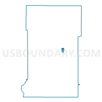
Crosby P-2 Voting District, Crow Wing County, Minnesota
About
Outline

Summary
| Unique Area Identifier | 601663 |
| Name | Crosby P-2 Voting District |
| County | Crow Wing County |
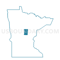
| State | Minnesota |
| Area (square miles) | 1.85 |
| Land Area (square miles) | 1.57 |
| Water Area (square miles) | 0.28 |
| % of Land Area | 85.12 |
| % of Water Area | 14.88 |
| Latitude of the Internal Point | 46.49332730 |
| Longtitude of the Internal Point | -93.96392740 |
Maps

Graphs
Select a template below for downloading or customizing gragh for Crosby P-2 Voting District, Crow Wing County, Minnesota


Neighbors
Neighoring Voting District (by Name) Neighboring Voting District on the Map
- Crosby P-1 Voting District, Crow Wing County, MN
- Irondale Twp. Voting District, Crow Wing County, MN
- Ironton City Voting District, Crow Wing County, MN
- Trommald City Voting District, Crow Wing County, MN
- Wolford Twp. Voting District, Crow Wing County, MN
Top 10 Neighboring County Subdivision (by Population) Neighboring County Subdivision on the Map
- Crosby city, Crow Wing County, MN (2,386)
- Irondale township, Crow Wing County, MN (1,134)
- Ironton city, Crow Wing County, MN (572)
- Wolford township, Crow Wing County, MN (379)
- Trommald city, Crow Wing County, MN (98)